Early Views of Quincy
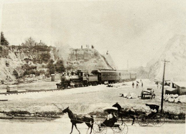
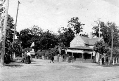
– A 1900 photograph of the first passenger train of the Wabash Railroad’s new track as it came through the cut in the bluff and headed north on Delaware before the curve which took it to the railhead at Sixth and York Streets. (Photo courtesy of Author)
Long before aerial photography, nineteenth-century civic boosters used bird's-eye-view prints to show off Quincy's prosperity and lure new investors. At least three of these prints were published, in 1859, 1860, and 1875. In dramatic panoramas, the prints render streets, parks, residential blocks, and factories in detail. They also give some idea of how the natural landscape must have looked before Quincyans filled in the stream beds and cut through the hills in building their city.
Architectural historian Paul Larson referred to the prints in his 1991 application to have the South Side German Historic District listed on the National Register of Historic Places. He called special attention to the effect that two unnamed streams had on the south side's development.
Stand on Jersey Street between 12th and 14th, on the south side of the Quincy Jr. High building, and you will notice that the land rises slightly in all directions. This low point is about where the 1860 print, View of the City of Quincy, Ill., places the origin of a creek that would eventually empty into the Mississippi near Payson Avenue. Larson wrote that the creek flowed almost directly west in a shallow gully between Jersey and York, then curved to the southwest before plunging underground near 7th and York Streets. It resurfaced east of 6th Street, south of Kentucky, as a spring feeding "a patchwork of marshy land with little attraction for prospective residents." The boggy stream turned again to the southwest close to 6th and State Streets. It then narrowed in a gradually steepening grade to pass through a gap in the bluffs at Payson Avenue. Today, this stream is directed into the sewer system, and the water gap it once carved through the bluffs is bridged over by the four-lane Gardner Expressway viaduct.
The 1860 print also pictures a second, shorter creek that joined the main branch just south of 5th and Ohio Streets. It surfaced from an underground spring east of 7th Street between Ohio and Payson and flowed directly west for about a block before angling to the northwest. Here both creeks eroded banks into the limestone that were so steep construction of Payson had to be halted between 7th and 6th Streets, and again west of 5th. Oddly enough, the 1859 birds-eye print shows the Payson segments as connected, with the street extending straight down to Front Street.
The print artists took great care to accurately depict and locate buildings and parks on what are essentially 3-D maps, they could not resist drawing in scenic, romantic versions of the Mississippi bluffs. In the 1878 print, the bluffs are transformed into cliff faces looming over Front Street at twice their actual height. The shallow gully mentioned earlier looks more like a gulch, with the "Quincy Brewery, Dick Bros, Props" buildings perched on the side.
A site next to a reliable source of potable water was essential for a brewery like Dick Brothers. As the creeks were directed into sewers and the swampy ground was filled in, the reclaimed stream beds attracted other types of industry that could be located away from the riverfront. Listing them by name, the 1878 print shows that manufacturing and processing firms were beginning to cluster at several locations on the longer branch. The City Spring Flour Mill is shown on the east side of 6th Street north of Kentucky. The Flachs & Riemann Soap Factory, at the southeast corner of 6th and Kentucky, belches black smoke from its chimney. The Empire Tobacco Works, the Eagle Foundry, and several machine shops, including the R.W. Gardner Shop, are grouped around 5th and Ohio Streets.
Some of the land farther downstream was too rough for improvement of any kind. As early as 1838, a plat of John Wood's First Addition to the Town had laid out Delaware Street in a straight diagonal from 3rd and Payson Streets up to 6th and State Streets, in order to avoid the abrupt slopes of the bluff to the northwest.
At the close of the nineteenth century, the factories and warehouses established along the creeks, and the course of the longer creek itself through the bluffs, made the stream bed the obvious route for the Wabash Railroad to take into the heart of the South Side.
The Wabash trunk line ran generally east-west south of the city. The company wanted a shipping terminal in Quincy that could be reached on its own track so it would no longer have to rely on the Chicago, Burlington & Quincy line that ran along the riverfront. Survey work for a spur up from East Hannibal began in 1897. The spur was completed in 1899.
In 1897, Wabash agents moved quickly to buy land on the north side of Delaware, and for switching points and industrial sidings, between Front and 3rd Streets south of Payson. In 1900, they also bought land on the east side of 6th between York and Kentucky.
When it reached the bottoms at Quincy, the spur went straight north along 3rd Street. It then curved through the gap in the bluffs to align with Delaware. After a curve along Ohio for about a block, it finally made a 90-degree turn onto 6th Street. An extra switch engine had to be added to help trains around the bend because the grade was steep and the curve tight.
The first passenger train made it through the gap on May 26, 1900. The event was commemorated in an often-reproduced photo of the locomotive as it steams up the curve onto Delaware. The train's destination was a railhead at the southeast corner of 6th and York Streets. A handsome passenger depot and a freight house just to its east would not be completed until 1903. Passenger service continued until 1934. The freight house was destroyed by fire ten years later. The last sections of Wabash track were pulled up decades ago, but you can see long concrete patches in the Delaware and Ohio Streets pavements where the line and some sidings used to run.
Sources
Birds Eye View of Quincy, ILL. [Lithograph] Philadelphia, PA: Duval & Sons, 1859.
Haerting and Ortloff. View of the City of Quincy, ILL. [Lithograph], St. Louis, MO: Gast Brothers & Company, 1860.
Landrum, Carl. “When the Wabash Made Its Move.” Quincy Herald-Whig, February 4, 1979.
Larson, Paul C. South Side German Historic District, Quincy, IL. National Register of Historic Places Nomination Form, Section 7. Washington D. C.: U. S. Department of the Interior, National Park Service, 1991.
Pauli, Clemens J. Map of Quincy, ILL. [Lithograph], Milwaukee WI: Beck & Pauli, 1878.
Simon, Gene. “When The Wabash Came Uptown.” The Wabash Flag [Newsletter], St. Peters, MO: Wabash Railroad Historical Society 4 no.4 (Fall, 1981).
Tom Fentem is a retired assistant city planner with the City of Quincy. He served as staff for the Quincy Preservation Committee.